• Skip to primary navigation
  • Skip to main content
  • Skip to footer
Nutty Hiker Adventures Logo

Nutty Hiker Adventures

Hike Every Hike Like It Is Your Last

  • Hiking >>
    • Hiking Articles
    • Hiking 101 >
      • 10 Essentials of Hiking
      • Types of Hikes
      • Trail Etiquette
      • Hiking Terms & Jargon
      • Hiking First Aid Kit
      • What to Bring On Every Hike
      • Pre Thru-Hike Checklist
      • Hacks to Lighten Your Backpack Weight
      • How to Avoid Norovirus While Backpacking
      • Choosing a Sleeping Bag Liner
      • How to Poop in the Woods
      • Gift Guide for Hikers
      • Books for Hikers & Backpackers
      • Movies About Hiking
      • Subscription Boxes for Hikers
      • Thru-Hiking Trails Bucket List – USA Edition
      • Your Hiking Questions Answered
    • Long Trails >
      • Appalachian Trail
      • BamatoBaxter
      • Greenbrier River Trail
      • Lone Star Hiking Trail
      • Pinhoti Trail
    • Rails To Trails >
      • Greenbrier River Trail
    • Gear Reviews
    • Ask Nutty Hiker
  • Camping >>
    • Camping Articles
    • Camping Gear Reviews
  • Survival >>
    • Survival Articles
    • Survival Gear Reviews
  • Destinations >>
    • By State >>
      • Arizona
      • Arkansas
      • Colorado
      • Georgia
      • Idaho
      • Kansas
      • Kentucky
      • Louisiana
      • Maryland
      • Nevada
      • New Mexico
      • North Dakota
      • Oklahoma
      • Pennsylvania
      • South Dakota
        • Black Hills National Forest
      • Tennessee
      • Texas
        • North Texas
        • Central Texas
          • San Antonio
        • East Texas
        • South Texas
        • West Texas
        • Texas State Parks
        • Guadalupe Mountains National Park
      • Utah
      • Virginia
      • Washington
      • West Virginia
    • The Ultimate Road Trip Checklist || Adventure Safely
    • Road Trips >>
      • The Ultimate Road Trip Checklist || Adventure Safely
      • Road Trip Ideas
    • State Highpoints
    • National Parks & Forests >
      • Black Hills National Forest
      • Guadalupe Mountains National Park
  • Motorcycle >>
    • Sturgis 2024
  • Photography >>
    • Latest Work
    • Photography Gear Reviews
    • Portrait Portfolio
  • ✎ Logbook >>
    • My Daily Antics
    • Ask Nutty Hiker
    • News >>
      • Outdoor News
      • Interviews
    • Resources >>
      • Recommendations
      • The Ultimate Road Trip Checklist || Adventure Safely
      • Hiking Essentials Checklist
      • Morse Code Converter || Send a Message in Morse Code
      • Military Time Converter
      • Message Encryption & Decryption
      • Message Transformer
  • Shop
    • My Artwork
    • Merch Store (T-Shirts & More)
  • Video’s
You are here: Home / Hiking / Pinhoti Trail / Pinhoti Trail #40: Dennis Mill TH to Northern Terminus

Pinhoti Trail #40: Dennis Mill TH to Northern Terminus

April 29, 2026 by Nutty Hiker Last Modified: April 29, 2026Leave a Comment

Reaching the Dennis Mill Trailhead was bittersweet; it meant I only had about 40 (ish) more miles left. From here to the Northern Terminus is mostly uphill when headed NOBO, so I, of course, decided I would do most of it SOBO.

I actually started out at GA 52 and worked my way down to Dennis Mill TH for the first section.

The trail near GA 52 now runs through a high-end mountain subdivision along a gravel road for several miles. The road (Tatum Lead Rd) itself, I believe, is “private,” meaning only residents and guests are allowed on it. I don’t know for sure, as I couldn’t read the sign as Suspenders drove past it on GA 52.

houses on a mountain top

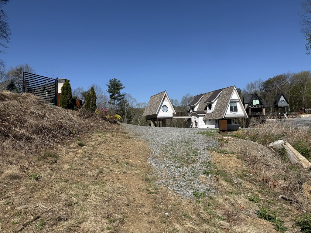
Anyway, it was sad to see, and I began to wonder if this means they will now have to reroute the Pinhoti. I believe the road was probably at one time a Forest Service road, as it turns into FS several miles down as it heads back into the woods.

My trek to Dennis Mill TH was rather uneventful; I was able to meet Suspenders about halfway for lunch, and the only people I saw were a couple of car campers.

The next day I headed from GA 52 NOBO to Mulberry Gap. Again, it was a pretty uneventful day, other than the humidity being absolutely horrendous. I was dripping with sweat; at least I think it was sweat, despite gentle climbs and a sizable chunk of downhills. In that aspect it was awful. I did run into several mountain bikers.

The next two days were where the fun began. I started at Buddy Cove, which is the highest point on the Pinhoti, and went down both sides.

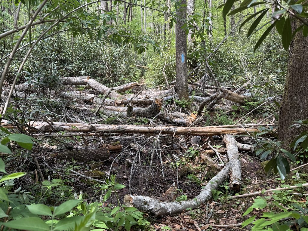
From Buddy Cove to Mulberry Gap was the most excitement I have had since returning.

There were a TON of blowdowns for a 3-mile section. There was one mile; it took me an hour to traverse!

several trees fallen, blocking a hiking path

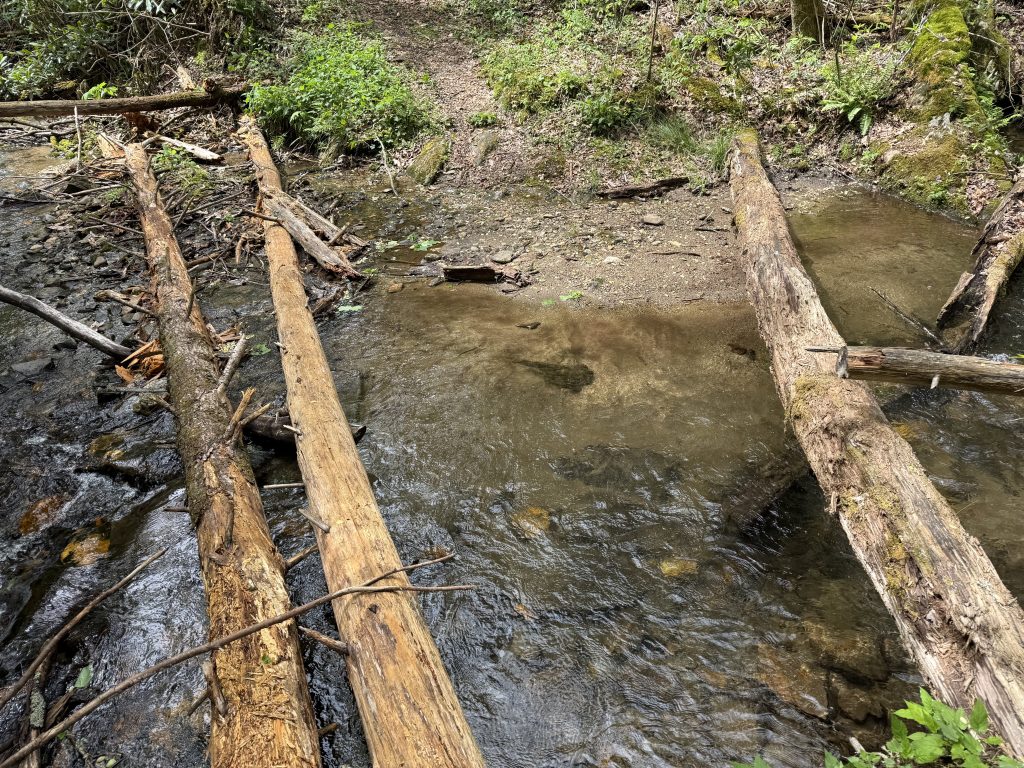
In addition to that, I had a TON of water crossings. Each water crossing is like a puzzle as you try to get a route planned in your head on how to make it across before getting your feet wet, lol. By the time I finally arrived to Suspenders at the end of the day, I was completely mentally exhausted.

three logs laying over a creek with water

My final day was three miles, mostly downhill. It was such a bittersweet day and I ended up slowing my pace at the end, just so I could take it all in.

As I began to do my final water crossing on the Pinhoti, one which I could not avoid getting my feet wet, I noticed a bunch of butterflies. I stopped a moment and then plowed right on into the water.

butterflies along a creek bed

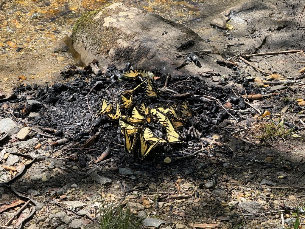
The other side was a mud pit, also something I was unable to avoid.

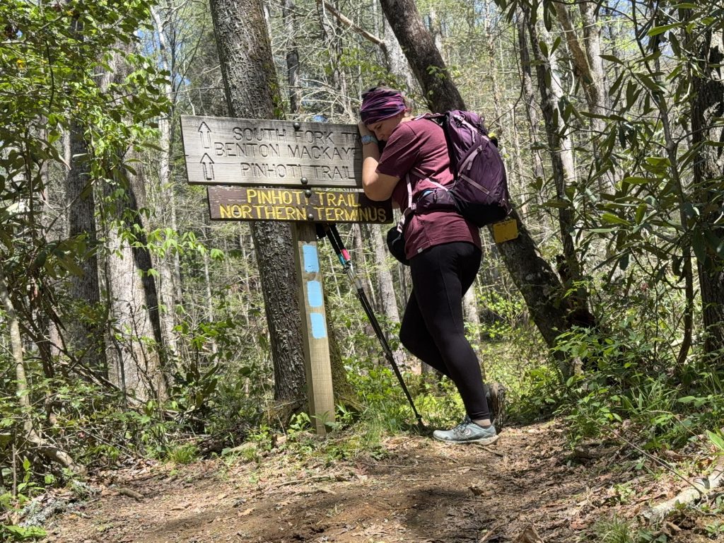
It wasn’t long before I saw my final blue blaze and made it to the Northern Terminus. I was finally done with this trail.

person hugging a sign for the pinhoti trail northern terminus

Exit Strategy

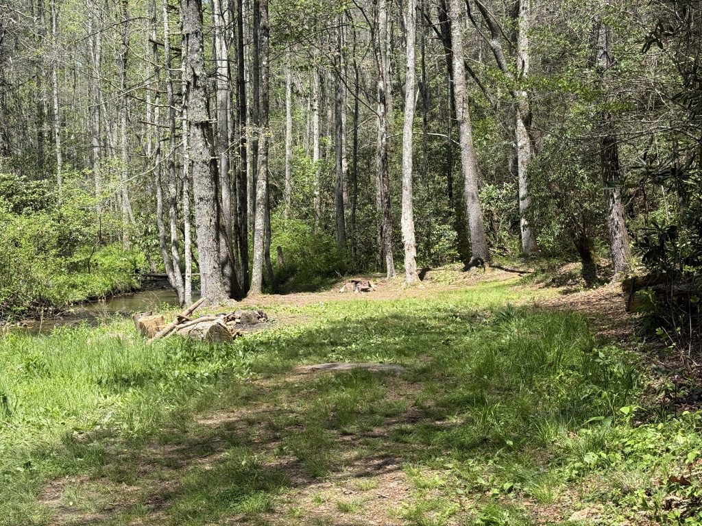
I opted to have Suspenders meet me about 0.25 miles from the trail near the Harkins Creek Campsite on the South Fork Trail. I basically had to back about .5 mile, and honestly, this route was the shortest distance to a pickup point. It’s also pretty easy to get to. The bonus is a campsite, so you can camp there and get picked up the next morning or relax while waiting for your ride. There is plenty of flat ground, sitting logs, and a fire pit, and it’s right next to a running stream.

campsite with logs and fire ring next to a creek

The other options are backtracking to Buddy Cove or get on the BMT and head to Watson Gap.

Whatever option you choose, you will need to make sure you plan it in advance, as there is no cell service.

Pinhoti #40 Video

Coming Soon!

Filed Under: Pinhoti Trail, BamatoBaxter, Hiking Tagged With: Hiking Trails

About Nutty Hiker

Bridget (known as Nutty Hiker on the trail) is a former journalist and newspaper editor turned professional wildlife/landscape photographer and outdoor adventure extraordinaire. She is also the face behind Nutty Hiker Adventures and has been a blogger since 2001! She loves to spend her time out on the trails racking up miles =) You can read more about her here.
FOLLOW: Facebook | TikTok | YouTube

Reader Interactions

Leave a Comment or Suggestion Cancel reply

Your email address will not be published. Required fields are marked *

Footer

FOLLOW

  • Facebook
  • Instagram
  • YouTube
  • RSS Feed
  • Amazon
  • Patreon

TIP JAR =)

This blog is my full-time job. I rely heavily on support from my readers. If you found my content useful and would like to help offset the cost of running this blog and my nutty adventures, please feel free to leave something in one of the tip jars below =)
Cash App
Venmo

DISCLOSURE

Per the FTC, This website contains affiliate links, advertisements, and sponsored posts. For reviews, I was provided with a complimentary copy of the item unless otherwise stated. As an Amazon Associate, I earn from qualifying purchases using the amazon links located on my website. Read my full policy here.

AWARDS/ASSOCIATIONS

OWAA Member Logo
Best Outdoor Blogs Feedspot Best Hiking Blogs

Copyright © 2026 — Nutty Hiker Advenures | Bridget Carlson • All rights reserved.
The links on this website are solely for the convenience of our visitors. Nutty Hiker does not endorse, operate, or control external websites.
Terms of Use • Privacy Policy• Disclosure• Contest Rules

  • Home
  • About
  • Subscribe
  • ☕ Support
  • ✉ Contact
  • Blog Archives
  • Recommendations
  • >> Resources