• Skip to primary navigation
  • Skip to main content
  • Skip to footer
Nutty Hiker Adventures Logo

Nutty Hiker Adventures

Hike Every Hike Like It Is Your Last

  • Hiking >>
    • Hiking Articles
    • Hiking 101 >
      • 10 Essentials of Hiking
      • Types of Hikes
      • Trail Etiquette
      • Hiking Terms & Jargon
      • Hiking First Aid Kit
      • What to Bring On Every Hike
      • Pre Thru-Hike Checklist
      • Hacks to Lighten Your Backpack Weight
      • How to Avoid Norovirus While Backpacking
      • Choosing a Sleeping Bag Liner
      • How to Poop in the Woods
      • Gift Guide for Hikers
      • Books for Hikers & Backpackers
      • Movies About Hiking
      • Subscription Boxes for Hikers
      • Thru-Hiking Trails Bucket List – USA Edition
      • Your Hiking Questions Answered
    • Long Trails >
      • Appalachian Trail
      • BamatoBaxter
      • Greenbrier River Trail
      • Lone Star Hiking Trail
      • Pinhoti Trail
    • Rails To Trails >
      • Greenbrier River Trail
    • Gear Reviews
    • Ask Nutty Hiker
  • Camping >>
    • Camping Articles
    • Camping Gear Reviews
  • Survival >>
    • Survival Articles
    • Survival Gear Reviews
  • Destinations >>
    • By State >>
      • Arizona
      • Arkansas
      • Colorado
      • Idaho
      • Kansas
      • Kentucky
      • Louisiana
      • Maryland
      • Nevada
      • New Mexico
      • North Dakota
      • Pennsylvania
      • South Dakota
        • Black Hills National Forest
      • Tennessee
      • Texas
        • North Texas
        • Central Texas
          • San Antonio
        • East Texas
        • South Texas
        • West Texas
        • Texas State Parks
        • Guadalupe Mountains National Park
      • Utah
      • Virginia
      • Washington
      • West Virginia
    • The Ultimate Road Trip Checklist || Adventure Safely
    • Road Trips >>
      • The Ultimate Road Trip Checklist || Adventure Safely
      • Road Trip Ideas
    • State Highpoints
    • National Parks & Forests >
      • Black Hills National Forest
      • Guadalupe Mountains National Park
  • Motorcycle >>
    • Sturgis 2024
  • Photography >>
    • Latest Work
    • Photography Gear Reviews
    • Portrait Portfolio
  • ✎ Logbook >>
    • My Daily Antics
    • Ask Nutty Hiker
    • News >>
      • Outdoor News
      • Interviews
    • Resources >>
      • Recommendations
      • The Ultimate Road Trip Checklist || Adventure Safely
      • Hiking Essentials Checklist
      • Morse Code Converter || Send a Message in Morse Code
      • Military Time Converter
      • Message Encryption & Decryption
      • Message Transformer
  • Shop
    • My Artwork
    • Merch Store (T-Shirts & More)
  • Video’s
You are here: Home / Destinations / South Dakota / Mount Coolidge Fire Tower & Lookout

Mount Coolidge Fire Tower & Lookout

January 17, 2018 by Nutty Hiker Last Modified: February 25, 20223 Comments

I love checking out old fire towers. Typically they require you to hike to them, however, you can drive to the Mount Coolidge Fire Tower. Just be careful driving the long, bending, and narrow road to get to it! In fact, on many other sites, they call it a drive on a terrifying road. It is a narrow road with sharp (blind) turns with sharp drop-offs on one side. So, it is important to go slow and watch for oncoming traffic!

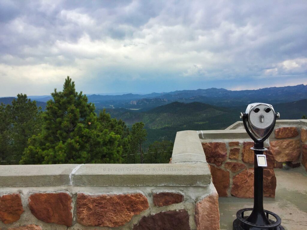
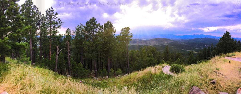
Once you have reached the top, you find yourself surrounded by breathtaking views.

Mount Coolidge Fire Tower & Lookout || Custer State Park, South Dakota

Mount Coolidge Fire Tower & Lookout || Custer State Park, South Dakota

Mount Coolidge Fire Tower History

Complete in the 1930’s and built from local stone, it sits upon a 6,023-foot peak and still used today as a fire tower and dispatch center.

Beware!

As I stated about, you will find yourself on a 1.7 mile very narrow and blind curve gravel road. Motorhomes, large vehicles, buses, etc… should NOT travel this road! Go slow and watch for approaching traffic!

Getting There

Mount Coolidge Fire Tower and Lookout is located in Custer State Park, 3 miles south of Hwy 16A on SD 87. Watch for the gravel road turnoff for the tower on SD 87!

Tips!

It is only open during the daylight hours (typically 9am-5pm) during the summer.

On a clear day, you can see the Badlands; 60 miles away!

Drive slowly! I know I already said it multiple times above, but I cannot stress this enough! It is a popular spot and you can’t see oncoming traffic around the curves.

Bring your camera! The views are amazing and there are a lot of photo ops! Make sure to take a panorama if you are completing items from the Ultimate Black Hills Bucket List!

Mount Coolidge Panorama from Black Hills Bucket List

SaveSave

SaveSave

Filed Under: South Dakota, Black Hills National Forest, Destinations Tagged With: Attractions

Reader Interactions

Comments

  1. Amanda Lee, Wescott says

    May 19, 2019 at 4:32 pm

    how long did this drive take? an hour or so or longer? trying to set up an itinerary!

    Reply
    • Bridget Carlson says

      May 28, 2019 at 7:29 am

      The drive from the main road did not take long (maybe 10 minutes if memory serves me correctly). I would definitely plan on an hour to allow for drive time and exploring once you reach the top.

      Reply
  2. J Lu says

    September 25, 2024 at 10:30 am

    We did drive this just last week of 9/16/24. It was very dry and loose gravel. Take heed of the warnings. There has been some washout and the road outside surface actually dips DOWN towards the cliff. It is NOT wide enough for two full size vehicles at a lot of spots as said. I had a Jeep GC and meeting a pickup was atrocious. Unfortunately, people don’t go down it with caution. If you get hit by someone coming down – you will go over the cliff. A pickup hogging the center coming down almost hit us, made the wife scream pretty good. I have driven other mountain roads out west but this road needs serious consideration. The blind curve near the top is quite something. The views are spectacular – don’t make it the last pictures on your camera. Be considerate and drive as close to the inside edge as possible for others when going down.

    Reply

Leave a Comment or Suggestion Cancel reply

Your email address will not be published. Required fields are marked *

Footer

FOLLOW

  • Facebook
  • Instagram
  • YouTube
  • RSS Feed
  • Amazon
  • Patreon

SUPPORT =)

This blog is my full-time job. I rely heavily on support from my readers. If you would like to help offset the cost of running this blog and my nutty adventures so I can continue to bring you travel & outdoor adventures, please feel free to donate =)
PayPal
Cash App
Venmo

DISCLOSURE

Per the FTC, This website contains affiliate links, advertisements, and sponsored posts. For reviews, I was provided with a complimentary copy of the item unless otherwise stated. As an Amazon Associate, I earn from qualifying purchases using the amazon links located on my website. Read my full policy here.

AWARDS/ASSOCIATIONS

OWAA Member Logo Best Outdoor Blogs Best Hiking Blogs

Copyright © 2025 — Nutty Hiker Advenures | Bridget Carlson • All rights reserved.
The links on this website are solely for the convenience of our visitors. Nutty Hiker does not endorse, operate, or control external websites.
Terms of Use • Privacy Policy• Disclosure• Contest Rules

  • Home
  • About
  • Subscribe
  • ☕ Support
  • ✉ Contact
  • Blog Archives
  • Recommendations
  • >> Resources