• Skip to main content
  • Skip to secondary menu
  • Skip to primary sidebar
  • Skip to footer
  • Home
  • About
  • Subscribe
  • ☕ Support
  • ✉ Contact
    • Contact Me
    • Request Product Review
    • Work With Me
    • Submit Guest Post
  • Blog Archives
Nutty Hiker Adventures Logo

Nutty Hiker Adventures

Hike Every Hike Like It Is Your Last

FarOut Guide Banner
  • Hiking >>
    • Hiking Articles
    • Hiking 101 >
      • 10 Essentials of Hiking
      • Types of Hikes
      • Trail Etiquette
      • Hiking Terms & Jargon
      • Hiking First Aid Kit
      • What to Bring On Every Hike
      • Pre Thru-Hike Checklist
      • Hacks to Lighten Your Backpack Weight
      • How to Avoid Norovirus While Backpacking
      • Choosing a Sleeping Bag Liner
      • How to Poop in the Woods
      • Gift Guide for Hikers
      • Books for Hikers & Backpackers
      • Movies About Hiking
      • Subscription Boxes for Hikers
      • Thru-Hiking Trails Bucket List – USA Edition
      • Your Hiking Questions Answered
    • Long Trails >
      • Appalachian Trail
      • BamatoBaxter
      • Greenbrier River Trail
      • Lone Star Hiking Trail
      • Pinhoti Trail
    • Rails To Trails >
      • Greenbrier River Trail
    • Gear Reviews
    • Ask Nutty Hiker
  • Camping >>
    • Camping Articles
    • Camping Gear Reviews
  • Survival >>
    • Survival Articles
    • Survival Gear Reviews
  • Destinations >>
    • The Ultimate Road Trip Checklist || Adventure Safely
    • State Highpoints
    • National Parks & Forests >
      • Black Hills National Forest
      • Guadalupe Mountains National Park
    • Arizona
    • Arkansas
    • Colorado
    • Idaho
    • Kansas
    • Kentucky
    • Louisiana
    • Maryland
    • Nevada
    • New Mexico
    • North Dakota
    • Pennsylvania
    • South Dakota
      • Black Hills National Forest
    • Tennessee
    • Texas
      • North Texas
      • Central Texas
        • San Antonio
      • East Texas
      • South Texas
      • West Texas
      • Texas State Parks
      • Guadalupe Mountains National Park
    • Utah
    • Washington
    • West Virginia
  • Road Trips >>
    • The Ultimate Road Trip Checklist || Adventure Safely
    • Road Trip Ideas
  • Motorcycle >>
    • Sturgis 2024
  • News >>
    • Outdoor News
    • Interviews
  • Video’s
  • Photography >>
    • Latest Work
    • Photography Gear Reviews
    • Portrait Portfolio
  • ✎ Logbook >>
    • My Daily Antics
    • Ask Nutty Hiker
  • Resources >>
    • Recommendations
    • The Ultimate Road Trip Checklist || Adventure Safely
    • Hiking Essentials Checklist
    • Morse Code Converter || Send a Message in Morse Code
    • Military Time Converter
    • Message Encryption & Decryption
    • Message Transformer
  • Shop
    • My Artwork
    • Merch Store (T-Shirts & More)
You are here: Home / Destinations / Texas / West Texas / The Ghost Town of Salt Flat, Texas

The Ghost Town of Salt Flat, Texas

July 14, 2016 by Nutty Hiker Last Modified: March 17, 2022Leave a Comment

About 90 miles east of El Paso, Texas sits the forgotten town of Salt Flat, Texas. The town was established in 1928 when Ed Hammack learned a new highway was to be built between El Paso and Carlsbad Caverns, New Mexico and it would pass through the area. However, today it’s a ghost town with abandoned buildings that time hasn’t forgotten about.

Salt Flat, Texas a West Texas Ghost Town just miles from the Guadalupe Mountains National Park and 90 miles east of El Paso.

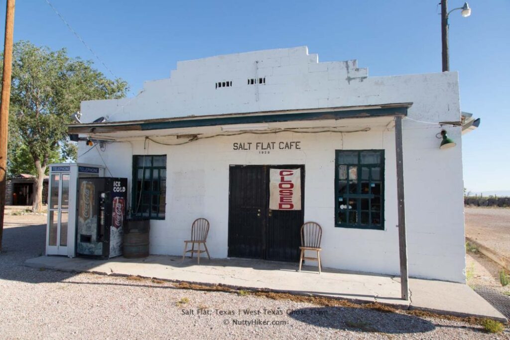
There is still a cafe (Salt Flat Cafe) which appears to be the only remaining intact building that we could see. It looked like it had been open recently, however, was closed when we arrived in July 2016.

It wasn’t until after we got back from our trip did we learn that the cafe is typically open, however, the owner has had some health issues and is not sure when she will be opening back up.

Salt Flat, Texas a West Texas Ghost Town just miles from the Guadalupe Mountains National Park and 90 miles east of El Paso.

There was also a house just a little further down from it that had a for sale sign. We stopped and without hesitation, I asked my husband to buy me that house.

Salt Flat, Texas a West Texas Ghost Town just miles from the Guadalupe Mountains National Park and 90 miles east of El Paso.

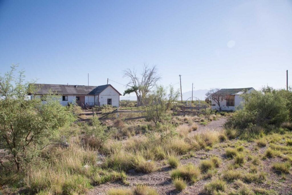
According to the internet, the population is 56, however, I find that pretty hard to believe! We didn’t see a single soul while we were there!

History

Mr. Hammack built a store (which also doubled as a bus station) and gas station which opened for business in 1929, shortly after traffic on the new highway began.

Arthur Grable built a store and gas station just a short distance down the road as well and eventually both men also opened cafes.

Salt Flat, Texas a West Texas Ghost Town just miles from the Guadalupe Mountains National Park and 90 miles east of El Paso.

An airstrip was built in the early 1930s after an American Airlines plane crashed in the nearby Guadalupe Mountains. The airfield was used for emergency landings when fog rolled into the mountains. It shut down in the early 1960s when new navigational equipment was developed which allowed planes to fly even in the most horrific of weather.

In the 1960’s at the height of it’s population, Salt Flat had a population of 125. By 1970 the population dropped to thirty-five.

Salt Flat gets its name from the Salt Flats it sits near:

Salt Flat, Texas a West Texas Ghost Town just miles from the Guadalupe Mountains National Park and 90 miles east of El Paso.

Filed Under: West Texas, Destinations, Texas Tagged With: Ghost Towns

Reader Interactions

Leave a Comment or Suggestion Cancel reply

Your email address will not be published. Required fields are marked *

Primary Sidebar

NEXT ADVENTURE BEGINS

BAMATOBAXTER
Currently on Trail as of April 3rd. We have started the Appalachian Trail portion of our BamaToBaxter Hike. Follow my journey on YouTube.

LATEST FROM THE TRAIL

Pinhoti Trail Day 29: Oakey Mountain

February 5, 2025 0

Recent Posts

  • Appalachian Trail: Pre-Trail Gear Changes
  • Pinhoti Trail Day 29: Oakey Mountain
  • Pinhoti Trail Day 28: Dugger Mountain & Plane Wreckage
  • Pinhoti Trail Day 26 & 27: Laurel Shelter to Burns Trailhead & a Zero Day
  • Pinhoti Trail Day 25: Pine Glen Campground to Laurel Shelter (& a Ghostly Tale)

Virtual Trail Angel

This blog is my full-time job. I rely heavily on support from my readers, whether it be from simply sharing my blog posts with their friends or through virtual trail magic (donations). If you want to help offset the cost of running this blog and support me while I am on trail or off on an adventure, you can do so through PayPal, CashApp, or Venmo.

PayPal
Cash App
Venmo

LATEST ADVENTURE

Sturgis 2024 Motorcycle

Sturgis 2024 Day 15-17: The Ride Home

September 25, 2024 0
Think Outside Subscription Banner
Battlebox Bannerpatagonia banner
Zero Balance Banner

Footer

FOLLOW

  • Facebook
  • Instagram
  • YouTube
  • RSS Feed
  • Amazon
  • Patreon

SUPPORT =)

This blog is my full-time job. I rely heavily on support from my readers. If you would like to help offset the cost of running this blog and my nutty adventures so I can continue to bring you travel & outdoor adventures, please feel free to donate =)
Donate to Nutty Hiker

DISCLOSURE

Per the FTC, This website contains affiliate links, advertisements, and sponsored posts. For reviews, I was provided with a complimentary copy of the item unless otherwise stated. As an Amazon Associate, I earn from qualifying purchases using the amazon links located on my website. Read my full policy here.

AWARDS/ASSOCIATIONS

OWAA Member Logo Best Outdoor Blogs Best Hiking Blogs

Copyright © 2025 — Nutty Hiker Advenures | Bridget Carlson • All rights reserved.
The links on this website are solely for the convenience of our visitors. Nutty Hiker does not endorse, operate, or control external websites.
Terms of Use • Privacy Policy• Disclosure• Contest Rules