• Skip to primary navigation
  • Skip to main content
  • Skip to footer
Nutty Hiker Adventures Logo

Nutty Hiker Adventures

Hike Every Hike Like It Is Your Last

  • Hiking >>
    • Hiking Articles
    • Hiking 101 >
      • 10 Essentials of Hiking
      • Types of Hikes
      • Trail Etiquette
      • Hiking Terms & Jargon
      • Hiking First Aid Kit
      • What to Bring On Every Hike
      • Pre Thru-Hike Checklist
      • Hacks to Lighten Your Backpack Weight
      • How to Avoid Norovirus While Backpacking
      • Choosing a Sleeping Bag Liner
      • How to Poop in the Woods
      • Gift Guide for Hikers
      • Books for Hikers & Backpackers
      • Movies About Hiking
      • Subscription Boxes for Hikers
      • Thru-Hiking Trails Bucket List – USA Edition
      • Your Hiking Questions Answered
    • Long Trails >
      • Appalachian Trail
      • BamatoBaxter
      • Greenbrier River Trail
      • Lone Star Hiking Trail
      • Pinhoti Trail
    • Rails To Trails >
      • Greenbrier River Trail
    • Gear Reviews
    • Ask Nutty Hiker
  • Camping >>
    • Camping Articles
    • Camping Gear Reviews
  • Survival >>
    • Survival Articles
    • Survival Gear Reviews
  • Destinations >>
    • By State >>
      • Arizona
      • Arkansas
      • Colorado
      • Idaho
      • Kansas
      • Kentucky
      • Louisiana
      • Maryland
      • Nevada
      • New Mexico
      • North Dakota
      • Pennsylvania
      • South Dakota
        • Black Hills National Forest
      • Tennessee
      • Texas
        • North Texas
        • Central Texas
          • San Antonio
        • East Texas
        • South Texas
        • West Texas
        • Texas State Parks
        • Guadalupe Mountains National Park
      • Utah
      • Virginia
      • Washington
      • West Virginia
    • The Ultimate Road Trip Checklist || Adventure Safely
    • Road Trips >>
      • The Ultimate Road Trip Checklist || Adventure Safely
      • Road Trip Ideas
    • State Highpoints
    • National Parks & Forests >
      • Black Hills National Forest
      • Guadalupe Mountains National Park
  • Motorcycle >>
    • Sturgis 2024
  • Photography >>
    • Latest Work
    • Photography Gear Reviews
    • Portrait Portfolio
  • ✎ Logbook >>
    • My Daily Antics
    • Ask Nutty Hiker
    • News >>
      • Outdoor News
      • Interviews
    • Resources >>
      • Recommendations
      • The Ultimate Road Trip Checklist || Adventure Safely
      • Hiking Essentials Checklist
      • Morse Code Converter || Send a Message in Morse Code
      • Military Time Converter
      • Message Encryption & Decryption
      • Message Transformer
  • Shop
    • My Artwork
    • Merch Store (T-Shirts & More)
  • Video’s
You are here: Home / Destinations / Louisiana / Driskill Mountain – Louisiana High Point

Driskill Mountain – Louisiana High Point

October 12, 2023 by Nutty Hiker Last Modified: October 12, 2023Leave a Comment

We got to knock out Driskill Mountain, which is the Louisiana High Point, back in July of 2021 (yes, I am still trying to play catchup on posts).

Article Contents

  1. Driskill Mountain History
  2. Trailhead
  3. Trip Summary
  4. Reaching the Top
  5. Heading Back Down
  6. Highpoint Stats
  7. More Information
    1. Getting There
    2. Red Tape
    3. Parking Area
  8. Video

Date Visited: July 04, 2021
Weather Conditions: Sunny & Warm
Temperature: 80 degrees
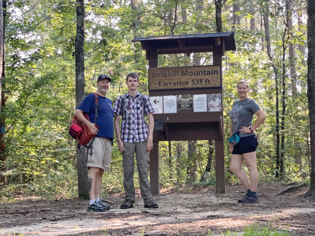
Elevation: 535 feet
Blaze Color: Blue


Driskill Mountain History

Driskill Mountain derives its name from James Christopher ‘Grancer’ Driskill (1817-1901), an individual who established his residence in the agricultural and forested terrain encompassing the mountain during the latter part of the 1830s, subsequent to his relocation from Macon, Georgia.

Over time, Mr. Driskill acquired ownership of an expansive 960-acre tract within the vicinity. In 1874, he generously contributed two acres of land, which presently serve as the site for the Mount Zion Presbyterian Church and the Driskill Memorial Cemetery. Presently, numerous descendants of Grancer Driskill continue to reside in close proximity to Driskill Mountain.

Trailhead

The trailhead is located behind the church and cemetery down a dirt road. Parking is at the church (do not attempt to drive down the dirt road as it is private property).

Trip Summary

The Driskill Mountain trail was easy and is perfect for beginners. The trail was pretty well marked all the way to the top. While there is no view at the top, it’s nice to be able to knock off a high point quickly. It is in the middle of nowhere, so be prepared to drive down backroads for a while.

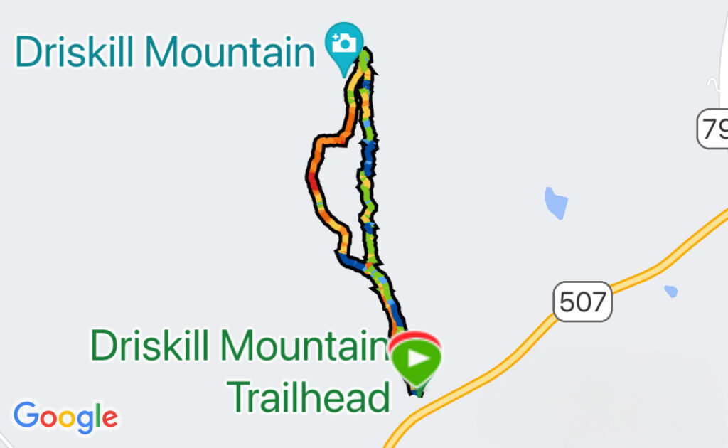
There are two ways to reach the top: via the Driskill Trail or via the False Mountain Trail. We took the Driskill Trail to the top and the Flase Mountain Trail back down to make a loop.

Driskill Mountain Trail Map

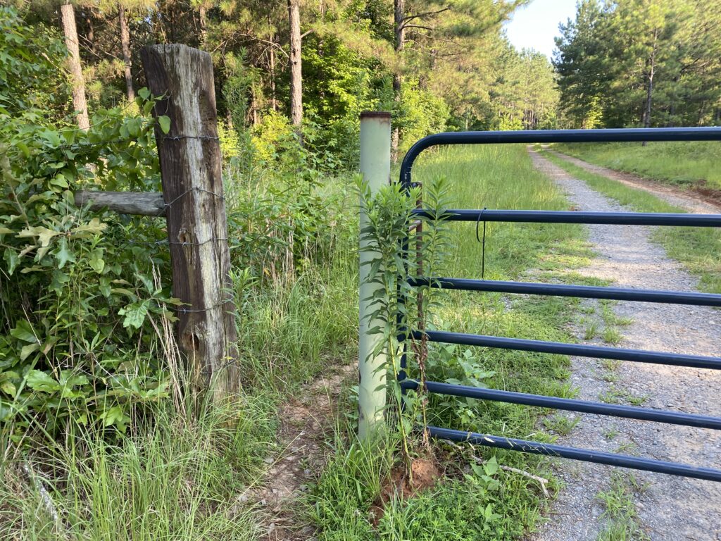
After we parked, we walked down what looked to be a private dirt road until we got to a gate. There is a walk-through portion open for hikers. You ARE supposed to go through it.

driskell trail gate nuttyhiker

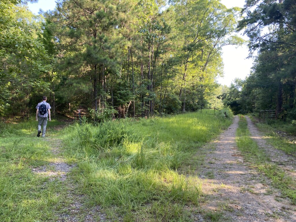
We continued on the private dirt road until we got to an area where it looked like a trail shot off to the left. You will take that trail, which is Driskill Trail. When we were there, the sign for the trail was off into the trail and not easily seen from the road.

driskell trail split nuttyhiker

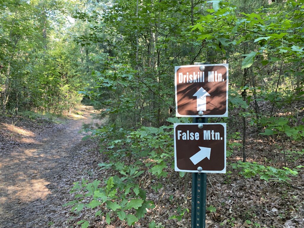
You’ll hike a short distance, and then you will come to yet another split. This is the Driskill Mountain Trail and False Mountain Trail split. Stay to the left to stay on Driskill Mountain Trail.

driskill mountain and fasle mountain trail split signs

Reaching the Top

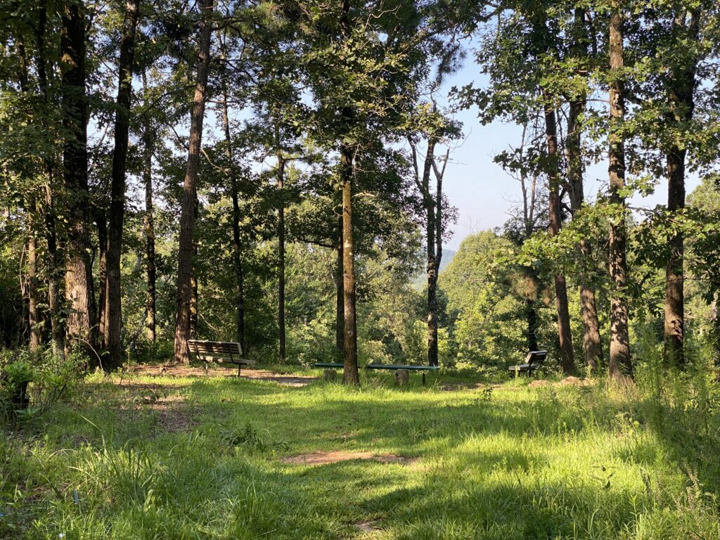
Once at the top of Driskill Mountain, you will see some benches, a high point sign, and a log book. We took our obligatory picture, signed the log book, and then did a little exploring to see if we could see a view anywhere.

Driskill Mountain - Louisiana High Point Sign

There was a sign to an overlook. I assume it’s better to view in the fall and winter when there is no foliage on the trees.

driskell trail overlook nuttyhiker

Heading Back Down

Do not follow the blue blazes behind the High Point sign if you want to take the False Mountain Trail back down. The correct trail is just left of the Driskill Trail.

If you decide to take the False Mountain Trail back down, be prepared to navigate without maps as it is not well marked, and many areas are overgrown. We ended up somehow getting off the trail several times. I would suggest that beginners not do this trail and head back down the Driskill Mountain Trail instead.

Highpoint Stats

STATE: LouisianaWHEN TO CLIMB: Anytime
DATE VISITED: July 04, 2021PERMIT REQUIRED: No
TYPE: Hike, Round TripFEE: None
LENGTH: 1.75 miles (out and back)HOURS OPEN: 24 Hours
DIFFICULTY: EasyELEVATION GAIN: 256 feet
TYPE OF TERRAIN: Compacted dirtELEVATION: 535 feet
Stats are according to my Garmin Fenix 5S watch

More Information

Getting There

From IH-20:

  • Take exit 69 for LA-151 S toward Arcadia
  • Turn South onto LA-151 S
  • Continue onto N Hazel St
  • Turn left onto LA-147 S/Jonesboro Rd
  • Continue to follow LA-147 S
  • Slight right onto LA-797
  • Turn right onto LA-507 S
  • Church Parking lot will be on the right

Red Tape

Keep in mind this is private property. There is no camping allowed. Be respectful and pack out what you pack in. Stay on the trail.

Parking Area

The parking area is in the church parking lot. The parking lot isn’t large, but even on a Sunday morning, we were the only ones there.

Video

Check out other state high points I have completed.


Disclaimer: These articles are here to serve others as a guide on their own outdoor & travel adventures. You use any advice given on this site at your own risk. Exploring & Hiking Hiking can be risky activities; fatalities and injuries do occur. You assume responsibility when you decide to visit or hike in a particular location. Not all trails, attractions, and travels are safe for everyone. What works for me, may not work for you. Do your own research on gear and destinations before proceeding. Information is accurate at the time of posting and is subject to change at any time.

Filed Under: Louisiana, Destinations Tagged With: Hiking Trails, State High Point

Reader Interactions

Leave a Comment or Suggestion Cancel reply

Your email address will not be published. Required fields are marked *

Footer

FOLLOW

  • Facebook
  • Instagram
  • YouTube
  • RSS Feed
  • Amazon
  • Patreon

SUPPORT =)

This blog is my full-time job. I rely heavily on support from my readers. If you would like to help offset the cost of running this blog and my nutty adventures so I can continue to bring you travel & outdoor adventures, please feel free to donate =)
PayPal
Cash App
Venmo

DISCLOSURE

Per the FTC, This website contains affiliate links, advertisements, and sponsored posts. For reviews, I was provided with a complimentary copy of the item unless otherwise stated. As an Amazon Associate, I earn from qualifying purchases using the amazon links located on my website. Read my full policy here.

AWARDS/ASSOCIATIONS

OWAA Member Logo Best Outdoor Blogs Best Hiking Blogs

Copyright © 2025 — Nutty Hiker Advenures | Bridget Carlson • All rights reserved.
The links on this website are solely for the convenience of our visitors. Nutty Hiker does not endorse, operate, or control external websites.
Terms of Use • Privacy Policy• Disclosure• Contest Rules

  • Home
  • About
  • Subscribe
  • ☕ Support
  • ✉ Contact
  • Blog Archives
  • Recommendations
  • >> Resources