Well, I finally got to knock out the Kentucky High Point. It only took me three tries to do so!
Article Contents
Why three tries for such an easy high point?
The first time I attempted to reach the Kentucky High Point was on my way back from my Mom’s farm in West Virginia. The morning I left, my husband let me know he was being taken by ambulance from his work to the hospital with fainting/dizziness and heart issues. The good news is he works for an ambulance service (as a mechanic, not an EMT; the mechanic job pays more, haha), so the response time was just seconds. Needless to say, I rerouted and drove straight back home to Texas.
The second time was again on the way back from my Mom’s. This time, it was my husband and me. As we made our way up the mountain, it began to snow heavily, and before you knew it, the road and ground were covered in inches of snow and ice.
We attempted to put the truck in 4×4 just to find out my 4×4 was not working (due to a bad module/harness that didn’t get replaced when I had repairs done from a tire blowout; that is a whole different story on its own). We eventually made it up the mountain as there was no where to turn around, but in no way were we going to be able to make it up the last 1.5 miles to the very top as that was on an unpaved road in unknown condition. Hiking it was not an option as I didn’t have my microspikes, so we slowly made our way down.
Third Time is a Charm
The third time is a charm, though! My husband and I attempted to do the Kentucky High Point, yet again, on my way back from my Mom’s. We had gear because we had just completed a backpacking trip, the 4×4 had been fixed, and it was 70 degrees out!

Date Visited: September 23, 2023
Weather Conditions: Sunny
Temperature: 73
Elevation: 4145 ft
Blaze Color: None
Black Mountain History
Located in Harlan County, Kentucky, Black Mountain reaches 4145 feet and is the Kentucky High Point.
In 1999, Kentucky purchased the mineral and timber rights to the summit in order to prevent future large-scale mining operations, which would leave the Kentucky high point intact and open to the public.
Penn Virginia Resources, a coal mining company, formerly owned the summit but allowed public access with the completion of a waiver. The summit is now owned by the State of Kentucky and no longer requires a waiver.
Trailhead
There is no dedicated trailhead for this hike as it isn’t an actual hiking trail but, instead, an old beat-up road that consists of gravel and broken asphalt. Park at the bottom in the overlook parking lot.
Kentucky High Point Trip Summary
The drive to the base of the summit was absolutely beautiful! Unfortunately, the only overlook or place to pull off is at the base of the summit at the Jebediah Memorial Overlook. It turns out that Ky-160 is also a popular motorcycle ride called the Dragon Slayer (we will be bringing the motorcycle back).
Once you get onto Black Mountain Ridge Road, which is the actual road to the Kentucky High Point summit, the road goes from asphalt to chunks of rock, gravel, and old asphalt. It’s a bumpy ride to the top, and sometimes you are next to sheer drop-offs. I’d hate to see what happens when vehicles meet each other going separate ways!
Once you reach the FAA Radar Tower, you know you are getting close.
Reaching the Top of the Kentucky High Point
The offshoot for the summit of the Kentucky High Point will be on the left shortly after the FAA Radar Tower.
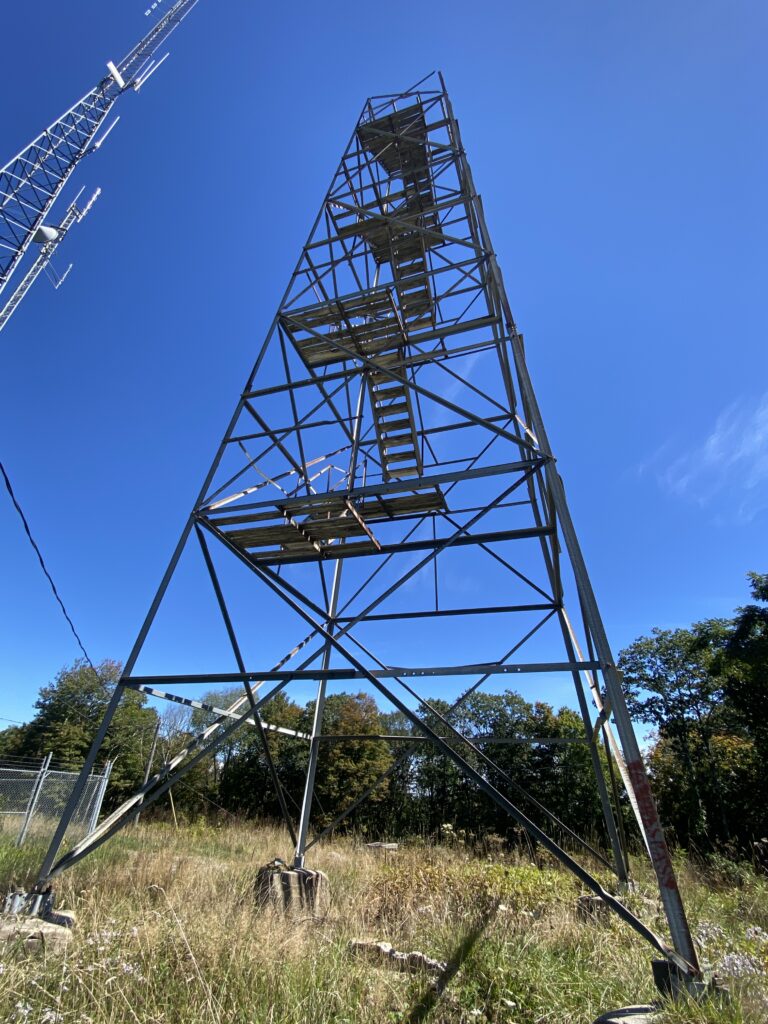
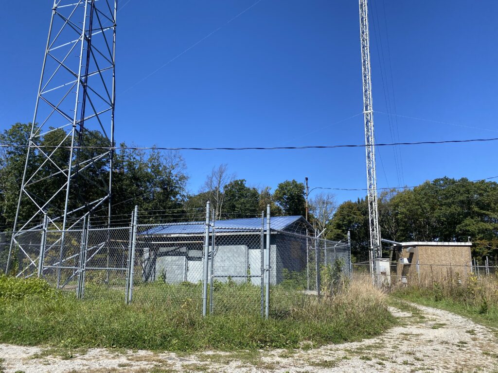
At the top, you can expect to see an old fire tower and several radio towers and transmitter buildings.
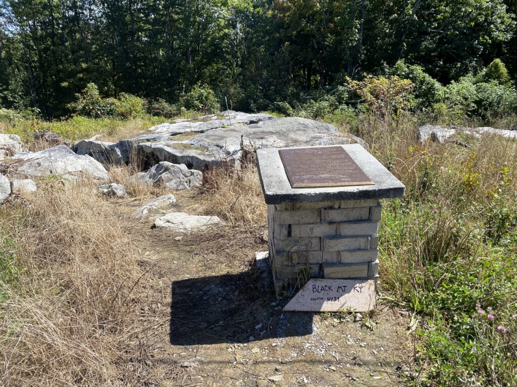
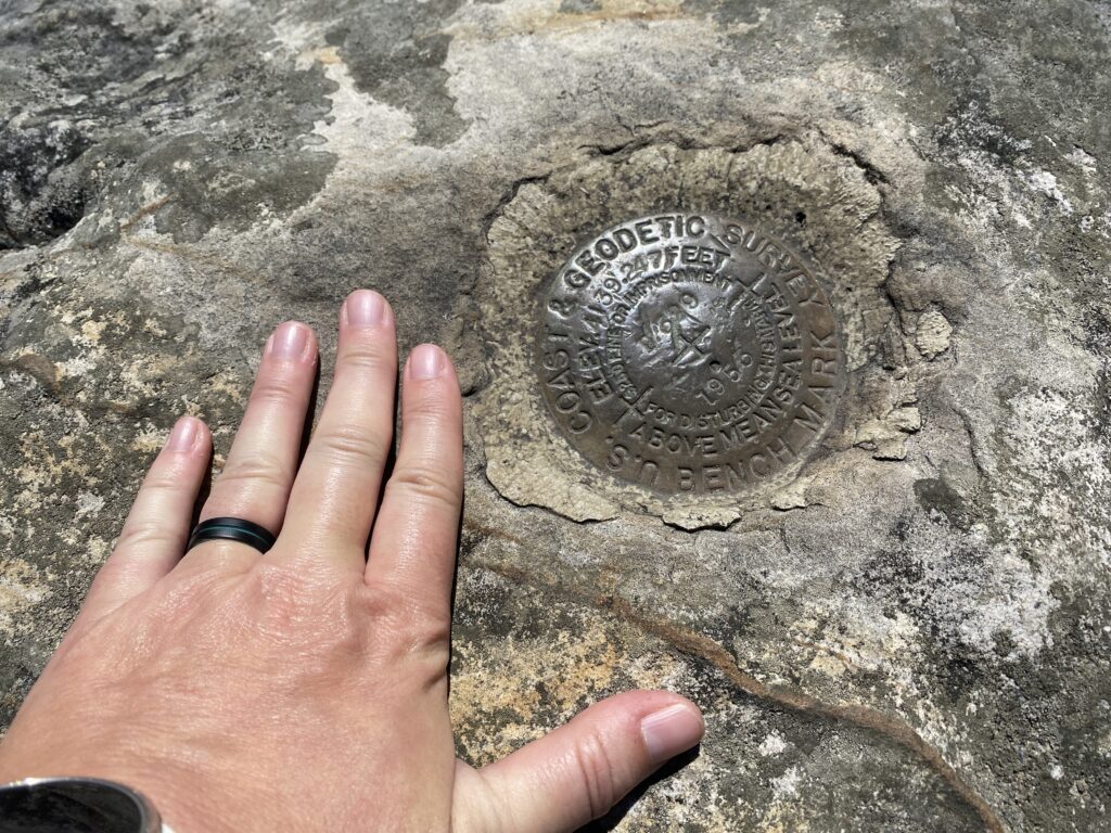
There is a plaque and apparently two USGS markers for the Kentucky High Point. The one I found was on the rock behind the marker. But apparently, the correct one is under the fire tower (placed there years later as the highest point). So, apparently, I will be going back to get a picture. I guess this mountain isn’t done with me yet! LOL.
Highpoint Stats
| STATE: Kentucky | WHEN TO CLIMB: Any – Plan to hike it instead of driving during the winter months |
| DATE VISITED: September 23, 2023 | PERMIT REQUIRED: No |
| TYPE: Drive up / Hike One-Way | FEE: NONE |
| LENGTH: 1.7 Miles | HOURS OPEN: 24 hrs |
| DIFFICULTY: Easy/Moderate | ELEVATION GAIN: N/A |
| TYPE OF TERRAIN: Broken up asphalt and gravel road with large ruts | ELEVATION: 4145 feet |
More Information
Getting There
It is pretty easy to get to the Kentucky High Point and can be found on any map. The Lot/Lan is 36.91420°N / 82.8939°W
Red Tape
Waiver No Longer Required – Several years ago, it was required that you sign a waiver in advance and send it to the Coal Company that owned the land that the high point sits on. That is no longer the case as the state took ownership of the high point in 2018.
Private Property – land alongside the “road” to the top is on private property, and trespassing is strictly prohibited. Stay on the road at all times.
One Way Up & One Way Down no matter what the map says – According to Google Maps, you should be able to continue onto Black Mountain Ridge Road at the top in order to drive to Lynch, Kentucky, instead of coming back down it to Hwy 160. The road is blocked with a gate shortly after the high point.
Parking Area
There is a parking area at the base of the final climb before a high clearance and 4×4 vehicle would be needed. You can easily see it on Google Maps; it is actually a pretty recently added overlook on the Virginia side. I would suggest not parking anywhere alongside the asphalt/gravel road to the top, as the areas on either side are private property.
Accessibility
High Clearance & 4×4 Needed – If you plan to drive the final 1.7 miles to the top, you will need a 4×4 and high clearance vehicle. Most spots aren’t bad, but there are several along the way that, at the minimum, a high-clearance vehicle would be needed.
Quick Facts
- You’ll pass a dome-looking tower on your right. This is an active FAA radar tower.
- The State took over the high point in 2018.
- There are no facilities anywhere near here, so keep that in mind.
- There is an old lookout tower at the summit. Supposedly, the state plans to rebuild it; however, at the time of this post, it is not climbable, and the bottom section of stairs has been removed.
- It is alternatively known as Katahrin’s Mountain
Video
I took a video of the ride to the top; however, it vanished. Instead, this video will be at the top and on the ride back down (via the dash cam). Not the greatest quality, but it will give you an idea of the road.
ADDITIONAL RESOURCES
Disclaimer: These articles are here to serve others as a guide on their own outdoor & travel adventures. You use any advice given on this site at your own risk. Exploring & Hiking Hiking can be risky activities; fatalities and injuries do occur. You assume responsibility when you decide to visit or hike in a particular location. Not all trails, attractions, and travels are safe for everyone. What works for me, may not work for you. Do your own research on gear and destinations before proceeding. Information is accurate at the time of posting and is subject to change at any time.


Leave a Comment or Suggestion