We’re back on the trail! Rain and mist greeted us as we hiked four miles uphill on a muddy trail, carrying heavier packs than usual. Our plan was to visit the Cloudland Hotel site, the Roan High Knob shelter, and Dr. Brown’s chimney before stopping for the night at a campsite just before Carver’s Gap.
| AT Miles | Bonus Miles | Total AT Miles Hiked | Miles Remaining |
|---|
6
1.2
149.1
2049.3
This time around, I have decided to research the area we will be hiking in to provide you with all the relevant history (if any) for that day’s hike.
Today we got dropped off later than we usually start. We left West Virginia in the wee morning hours and were dropped off at Hughes Gap (thanks, Pops) around 12:30 pm. A huge thank you to my step-dad, who drove us down there and then made the 7-hour trip back!
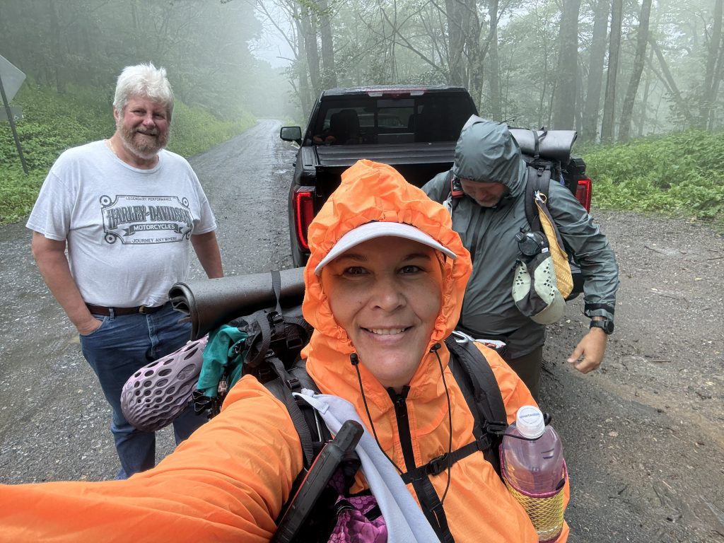
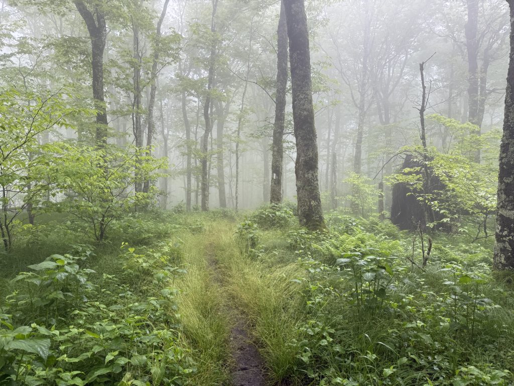
Of Course, it’s the first day back, and it has decided to rain and mist.
Like most days, we begin the day going up. No warming up the legs or lungs. Just up, up, and more up. Four miles up, to be exact. Thankfully, it was a gentle incline.
The trail was so muddy and looked like a pond or river in some places. Our packs were heavier than normal because we decided to carry four days of food, and I had 3 1/2 L of water like a dumbass. I was worried that we would be super slow since we had been off trail for almost a month (if you include the rainy days that we were off and then trail days) However, we kept our uphill pace at about a mile and a half an hour, which is actually our regular pace and that was in the rain hiking through mud and water with heavier than normal packs.
We finally made it to the top, where the Cloudland Hotel site used to be; however, the Cloudland Hotel site trail was closed, and we were unable to access it. Apparently, it’s been closed since Helene, so I’m not sure how other YouTubers have been able to show it.
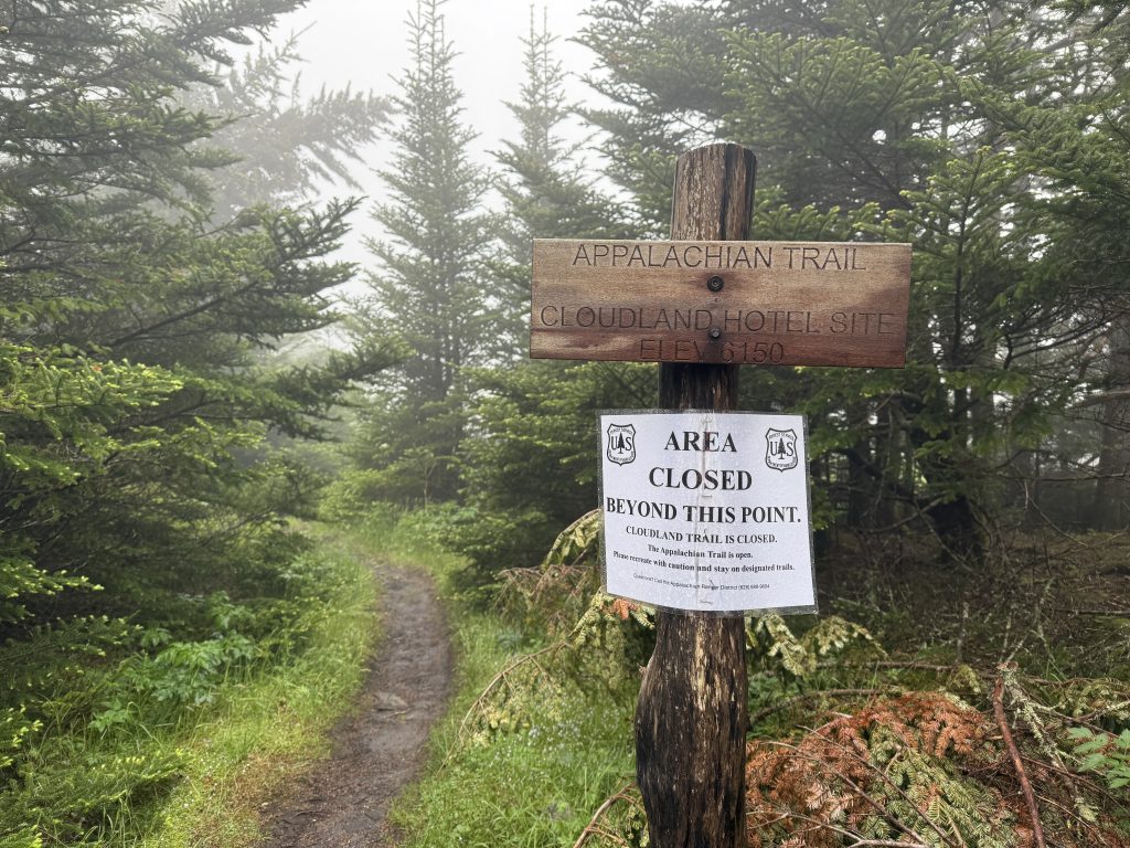
We were really upset about not being able to see it because I had a whole history lesson prepared for it that I wanted to discuss in today’s video, but we chose to obey the closure order and not continue.
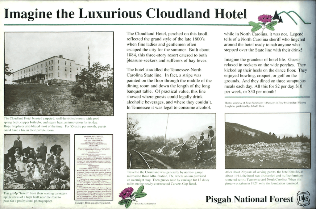
Cloudland Hotel History – Mile 378.6
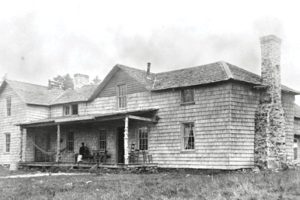
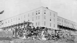
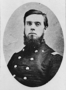
A 20-room spruce log lodge was built atop Roan Mountain in 1877 by former Civil War general and mining tycoon John T. Wilder. Quickly seeing the value in providing a summertime escape, he began construction on a much larger hotel near the log lodge in the early 1880s. The Cloudland Hotel was completed in 1885 and was billed as a health resort for individuals suffering from hay fever. Rates were $ 2 per day, $10/week, or $30/month.
The hotel stood on the state line, with a white line painted on the floor in the dining room. Alcohol was legal in Tennessee but illegal in North Carolina, so drinks were served only on the Tennessee side of the border. The steep operational costs of running a mountaintop hotel ultimately led to Cloudland’s downfall.
By 1910, the hotel had been abandoned and rapidly descended into disrepair. Wilder sold the establishment shortly before his passing, and the new proprietor auctioned off its deteriorating rooms one by one. By 1927, it had reduced to nothing more than a heap of rubble.
All that remains today of the site is a historical plaque, along with parts of the foundation.
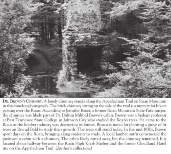
We made our way to Roan High Knob shelter so I could get some video of that and also try to find the survey marker. The shelter wasn’t much further down from the Cloudland hotel site, and before we got there, we came across a chimney.
It was extremely old, and I thought it might be part of one of the old hotel sites. However, Jerry reminded me that there was another chimney that people always photographed, and didn’t I have the information on it?
He was right. I didn’t think we would come to it that soon, but I looked in my phone to find the picture of the chimney’s history. It was Mr. Brown’s chimney.

Dr. Brown’s Chimney – Mile 378.7
Now, the actual history of this chimney is largely hearsay; no one appears to have any proof to substantiate any of these claims. However, here are some of what I have found:
- It was once the stables for the Cloudland Hotel
- It was a caretaker’s cabin for the Cloudland Hotel
- It was a 19th-century cabin that ended up abandoned, and then in the 1950s was occupied by an old hermit who was known for being cranky with “trespassers”. It eventually just fell apart.
- Most likely: Dr. Brown’s Chimney.
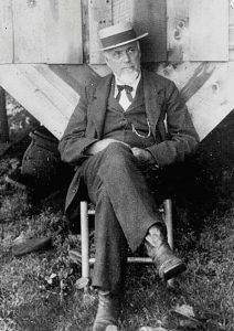
According to Jennifer Bauet, a former Roan Mountain State Park ranger, the chimney was likely part of Dr. Dalton Milford Brown‘s cabin. Brown was a biology professor at East Tennessee State College in Johnson City who studied the Roan trees. He came to the Roan as the lumber industry was destroying its forest. Brown is noted for planting a grove of fir trees on Round Bald to study their growth. The trees still stand today. In the mid-1930s, Brown spent days on the Roan bringing along students to study. A local lumber outfitter constructed a cabin for the professor with a chimney. The cabin likely rotted away, but the chimney remains. It is situated approximately halfway between the Roan High Knob shelter and the former Cloudland Hotel site on the Appalachian Trail.
We continued our way to the shelter. Once we reached the turnoff to the shelter, I looked at the weather and noticed that a thunderstorm was approaching. There were also supposed to be scattered thunderstorms the following morning, when we would be hiking the bald areas of the Roan Highlands.
We decided to head to Erwin, Tennessee, to the Super 8 and wait it out; we didn’t want to be on a bald mountain with lightning. It turned out to be a blessing in disguise, as there was a police stand-off the next morning, exactly where we had planned to camp (always listen to your gut). So while Jerry found us a shuttle driver, I headed to the Roan High Knob shelter area.
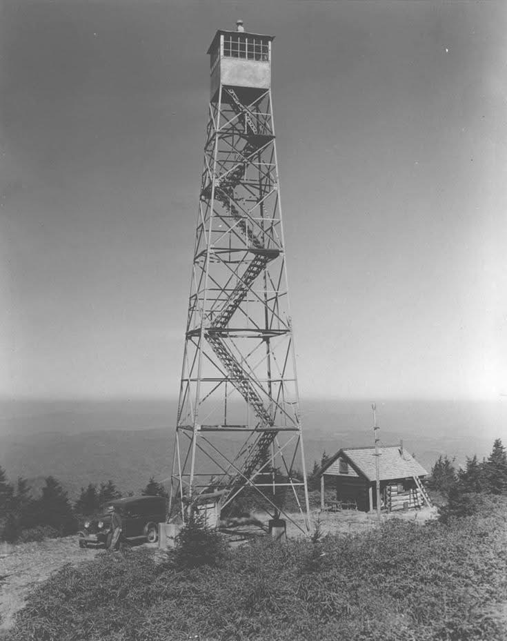
Roan High Knob Shelter & Fire Tower – Mile 379.3
The Roan High Knob shelter is currently closed for renovations, but I was able to take pictures from the outside and also spent some time searching for the survey marker.
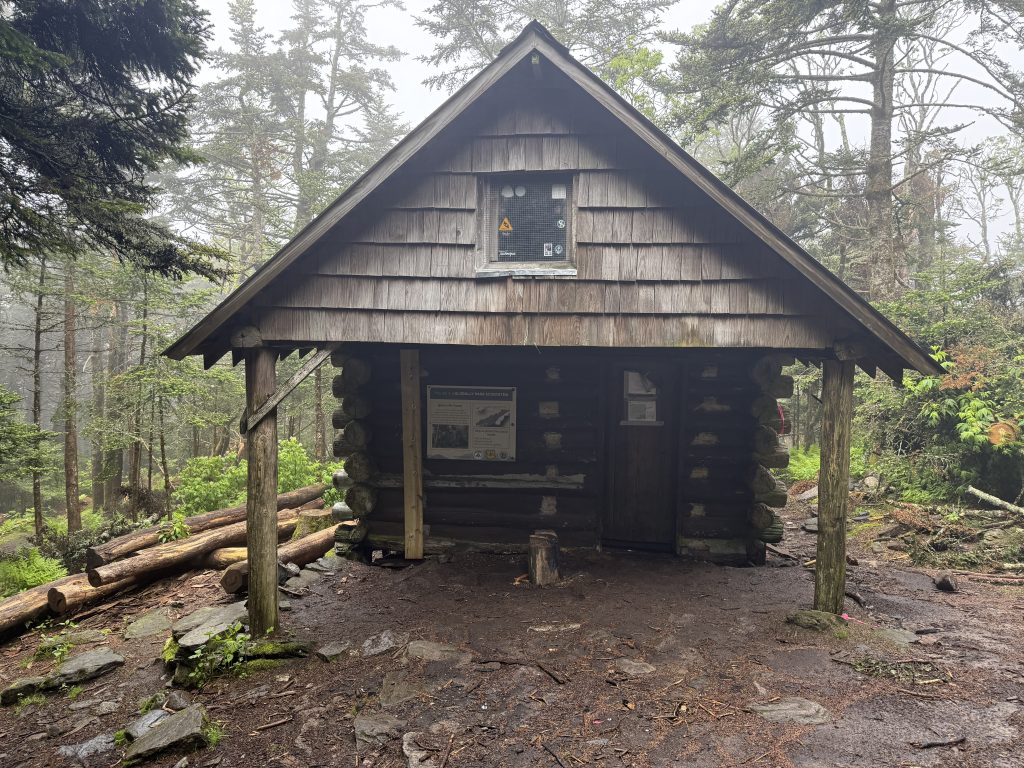
I never found the survey marker, but after researching it again, I discovered that I had actually found it; however, it was covered with downed trees, limbs, and pine needles, so I couldn’t see it.
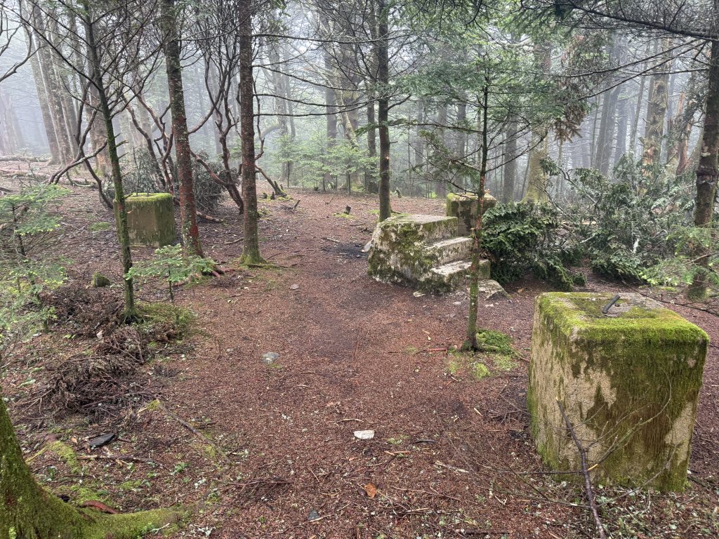
There are also remnants of the old fire tower that once stood here.
Roan High Knob & Shelter History
Roan Mountain, standing at 6,285 feet according to the survey marker, straddles the border between Tennessee and North Carolina. It features the world’s largest natural rhododendron garden and boasts the longest stretch of grassy bald in the Appalachian Range. As the 15th highest peak in the eastern United States, it holds significant prominence in the region.
According to a Native American legend, a great battle once took place at the summit, leaving the rhododendrons stained crimson and certain areas of the mountain treeless. Near the summit, there is a shelter that is the highest one on the Appalachian Trail.
In 1933, the Civilian Conservation Corps constructed a fire tower and a fire warden’s cabin at Roan High Knob. While the tower proved ineffective for spotting fires and was short-lived due to its frequent location above the clouds on overcast days, the cabin was renovated in 1980 and again in 2003. It now serves as the Roan High Knob Shelter. However, the shelter is currently closed for renovations that were interrupted when Hurricane Helene struck and caused significant damage to the area.
Once I finished looking around, I headed back down to Jerry, who told me he had found a shuttle, and we had about 45 minutes to make it 1.5 miles downhill through all the mud and water. Typically, this would not be an issue, but the terrain was extremely rocky and muddy. Plus, it was slippery because of the rain and fog, so we had to take our time.
We didn’t think we would make the 5:30 pm timeframe so he texted our shuttle driver to let him know we were coming down right now, but if we’re not there right at 5:30, we will be there very soon.
We stepped out of the woods and into the parking lot at Carver‘s Gap Right at 5:30.
However, on the way down, Jerry took a pretty bad fall on a slab of rocks; thankfully, there were no lasting injuries. My knees were aching like crazy. They needed ice. We are happy we made this decision to go ahead and go into town. We’d rather ice our injuries now, instead of trying to suffer through it and possibly cause further injury.
Overall, the day was good, other than the rain, the mud, and the trail that was nothing but ponds and rivers. For our first day back, I think we did pretty good. I expected us to go a lot slower than we did, but overall, we covered 7.2 miles (according to my watch) in 5 1/2 hours.
The next day, we ended up taking a Zero due to weather and the fact that they had closed the Gap because of a police standoff.


Leave a Comment or Suggestion