When I scouted places for our 2017 Road Trip (based on how much hiking I could get in) I realized the Black Hills of South Dakota was going to be our main stop when I stumbled upon Black Elk Peak (formally known as Harney Peak), which is the highest point east of the Rocky Mountains. While hiking Black Elk Peak isn’t a strenuous hike, it also isn’t for the faint of heart either.
We didn’t hike it right away and instead waited about a week before knocking this off of our Black Hills Bucket List.
We got up early and drove to Custer State Park to the trailhead and began our journey at about 0730. BTW, if you will be in the area for longer than a day, just get the annual pass to Custer State Park to save a ton of money in entrance fees!
The trail starts off easy and slowly begins to ascend where it then begins to descend and then ascend and then descend. You get the point! A whole bunch of ups and downs! I didn’t realize how out of shape I was until I did this trail! Of course, I am also used to only hiking the trails here in Central Texas which are all relatively flat with at the most a 200 ft elevation gain.
The trail is beautiful and has a ton of good photo ops, so make sure you bring your camera. Also, make sure to bring plenty of water, snacks and if you are going to make a day of it, also a lunch. We decided to have our lunch break at the top of the peak!
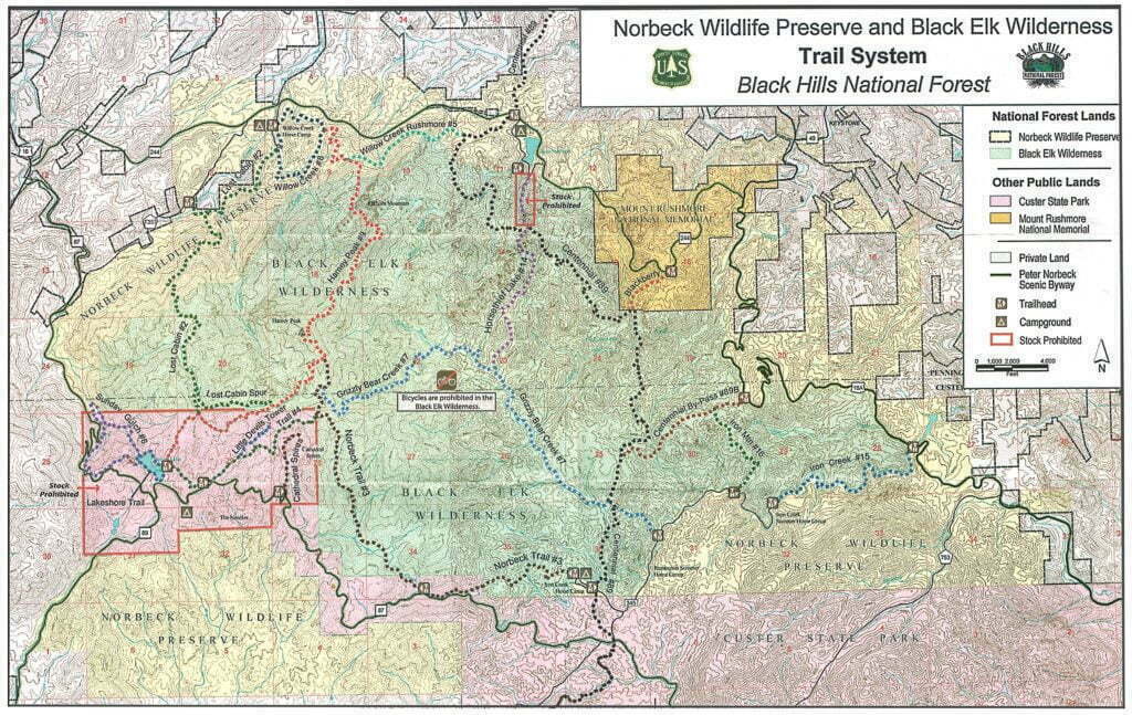
There are several different ways that you can reach the peak, however, the most common two are the North and South approach. The most used is the South approach trail (No 9) from Sylvan Lake. The North approach trail (No 9) from Willow Creek Horse Camp is longer and more strenuous but is also more scenic and less traveled.
Our Route
Our route started at Sylvan Lake on Trail No 9 to the peak. Coming back, however, we took Trail No 9 to Trail No 3 to Trail No 4 back to Sylvan Lake. So we essentially did a loop. Looking at the map below, we did red, brown, to green. We did a total of about 7 miles with an elevation gain of 1400 ft.
Video of Hiking Black Elk Peak
Instead of putting a million pictures within this post, I added them to the end of this video. This will give you a pretty good idea of what the trail is like. Excuse my poor video-making skills, I am still learning!
Tips
Bring plenty of water! Especially during summer. The trail can work up a sweat!
Bring snacks and a lunch. You will be happy you took the time to stop and eat lunch at the peak!
Bring a camera. There is too much beauty for you not to!
Remember trail etiquette. I don’t know how many times we were going up and the people coming down were not yielding, which means we had to stop and move aside instead of the other way around!
During summer the trails to the peak are crowded. Even during the week. Start early as possible and be prepared for a ton of noise at the top from kids (mostly teenagers). Or use the Northern approach to the trail (it will still be crowded and noisy at the peak).
Watch your children! Other than the fact that you are on top of a mountain in which they can fall off, I also noticed a lot of parents allowing their children (of all ages) to run freely interfering with others, messing with the fabric on the trees (which are prayer ties left behind by local Native Americans), and leaving trash.
Remember this is a sacred holy site! Again leave the prayer ties on the trees alone, keep the noise level to a minimum, pack out what you have packed in, and don’t remove anything (even rocks) from the area! The peak is sacred to many Native tribes who often hold religious ceremonies here, show some respect!
History of Black Elk Peak
Originally called Harney Peak, the name was changed to Black Elk Peak on August 11, 2016, by the Federal Board of Geographic Names to honor Black Elk, an Oglala Lakota Sioux Indian who is said to have received a great vision while he was on top of Harney Peak. He is also believed to have survived the Battle of Little Bighorn and the Wounded Knee Massacre.
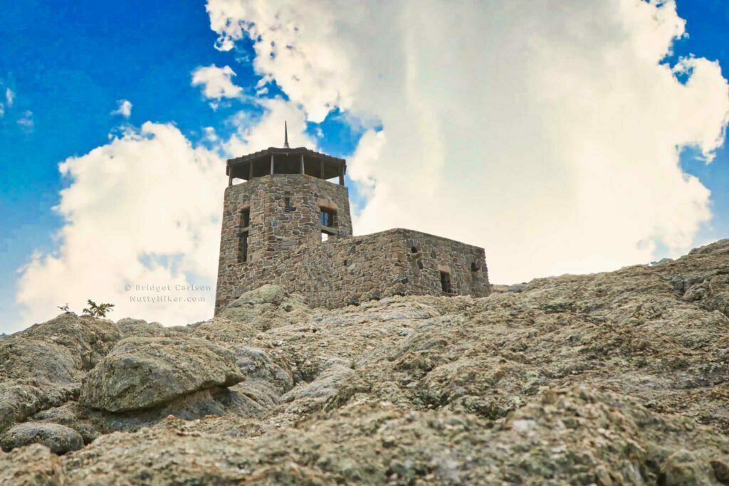
Black Elk Peak, which is located in the Black Elk Wilderness area of the Black Hills, has an elevation of 7,242 feet and is the highest point east of the Rocky Mountains. In fact, you won’t find a higher point until you reach the French Pyrenees.
The fire lookout that sits on top of Black Elk Peak was built by the Civilian Conservation Corps in 1939 and used until 1967. While it is no longer in use today, you are still able to tour it once you reach the peak. The view from the tower allows visitors to view land in 4 different states – South Dakota, Nebraska, Wyoming, and Montana.


I love hiking and love that this guide shows me places to hike where I never would’ve thought to go otherwise! Great guide!
xoxo
Annie
I have not hiked in awhile, well since I moved out os PA to ohio. It so flat here that you really cant hike. This post inspired me to go home and hike in the mountains of PA!
Definitely a fabulous hike! Nice tips and it’s fun to get a glimpse of the trail. Do you know what the mileage and elevation change of this hike was?
The route we took was roughly 7 miles round trip with about a 1400 ft elevation gain =)
Looks like you had a wonderful time. There are plenty of places to hike here and just maybe I will get past my heights challenge and go hiking.